
MBRSC releases first images from MBZ-Sat and Etihad-Sat

- MBRSC releases first images from MBZ-Sat and Etihad-Sat, ushering a new era in UAE Satellite Capabilities
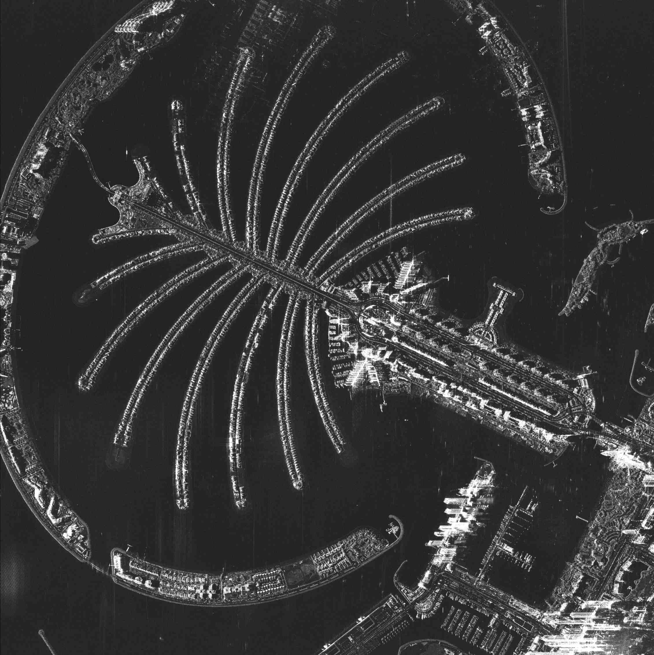
The Mohammed Bin Rashid Space Centre (MBRSC) has released the first set of images captured by MBZ-SAT and Etihad-SAT, coinciding with World Space Week 2025. The unveiling signals a major milestone in the UAE’s satellite imagery capabilities and strengthens the nation’s ability to deliver world-class Earth observation data for civil, infrastructure, maritime, and environmental monitoring applications. World Space Week was declared by the United Nations (UN) General Assembly to celebrate the contributions of space science and technology to the betterment of the human condition.
MBZ-SAT and Etihad-SAT represent distinct yet complementary technologies, working in tandem to provide a more comprehensive picture of Earth than ever before. Named in honour of H.H. Sheikh Mohamed bin Zayed Al Nahyan, President of the UAE, MBZ-SAT, which was launched in January 2025, is the most advanced satellite in the region using optical imaging. Etihad-SAT, launched in March 2025, is the Centre’s first Synthetic Aperture Radar (SAR) satellite, designed to capture data in all weather and lighting conditions. Together, these satellites deliver consistent, high-quality data that can be used to inform decision-making across critical sectors, from disaster response to smart agriculture and infrastructure development.
H.E. Hamad Obaid AlMansoori, Chairman, MBRSC, said, “The release of these first images from MBZ-SAT and Etihad-SAT reflects the strategic vision of our leadership and the dedication of our Emirati engineers. By combining optical and radar technologies, the UAE is not only meeting its own needs but also contributing vital solutions to global challenges. This achievement represents a new chapter in the UAE’s journey to become a pioneering force in satellite technology and space innovation.”
H.E. Salem Humaid AlMarri, Director General, MBRSC, said, “MBZ-SAT and Etihad-SAT are not isolated achievements, but part of a unified effort to build a comprehensive national capability in satellite development and Earth observation. The release of these images demonstrates our capacity to deliver advanced, reliable data that supports multiple domains. It also signals our commitment to developing a new generation of satellites that serve both the UAE and the wider world.”
MBZ-SAT: The most advanced satellite in the region
Weighing 750 kilograms and measuring 3m x 5m, MBZ-SAT is the result of extensive work by Emirati engineers from MBRSC. Local manufacturers also played a crucial part, with 90% of its mechanical structures manufactured in the UAE. It is equipped with one of the highest-resolution cameras in the region, capable of capturing images with double the precision of previous models.
The satellite’s innovative systems include an advanced electric propulsion unit, a star-tracking navigation system with metre-level accuracy, and data transmission rates four times faster than previous generations. Its onboard scheduling and processing allow images to be delivered within two hours of capture, which is a tenfold increase in efficiency. These capabilities make MBZ-SAT a powerful tool for monitoring environmental changes, managing infrastructure, and supporting disaster relief operations.
Beyond its technical advancements, the satellite’s development involved collaborations with local industries such as Strata, EPI, Rockford Xellerix, Halcon, Falcon and EGA, reinforcing national capabilities and transferring valuable knowledge to Emirati talent.
Etihad-SAT: MBRSC’s first SAR satellite
Etihad-SAT represents a major leap in the Satellite Development Programme, being the first SAR satellite developed by the Centre. Unlike traditional optical satellites, SAR satellites use radar signals to capture high-resolution images regardless of atmospheric conditions, time of day, or cloud cover.
The satellite is equipped with three imaging modes: spot mode for detailed views of small areas, scan mode for wide-area coverage, and strip mode for extended regional monitoring. These capabilities allow Etihad-SAT to deliver data that is indispensable for maritime navigation, detecting oil spills, monitoring natural disasters, and supporting precision agriculture.
The data collected by Etihad-SAT is processed with advanced artificial intelligence systems, which enhance the accuracy, speed, and usability of the imagery for government agencies, research institutions, and private sector partners. Its development also reflects MBRSC’s strategy of leveraging international collaboration, with Emirati engineers working closely with South Korea’s Satrec Initiative to finalise design and manufacturing while ensuring knowledge transfer to local teams.
Diverse satellite ecosystem
With the release of the first images from MBZ-SAT and Etihad-SAT, MBRSC underscores its commitment to creating a diversified fleet of satellites that deliver unique but interconnected capabilities. The integration of optical and radar imaging represents the UAE’s ability to build a resilient system that can respond to urgent global challenges, from climate change to food security and urban development. The achievement also signals the UAE’s growing role as a global space technology leader, offering advanced, reliable satellite imagery that can benefit not only the nation but also the wider international community.
More on these topics
Most Recent News

Hamdan bin Mohammed launches AED 1billion International Space Cooperation Programme to support space research and development

Brand Dubai launches ‘Eid Blooms and Envelopes Guide’ ahead of Eid Al Adha

 For an optimal experience please